
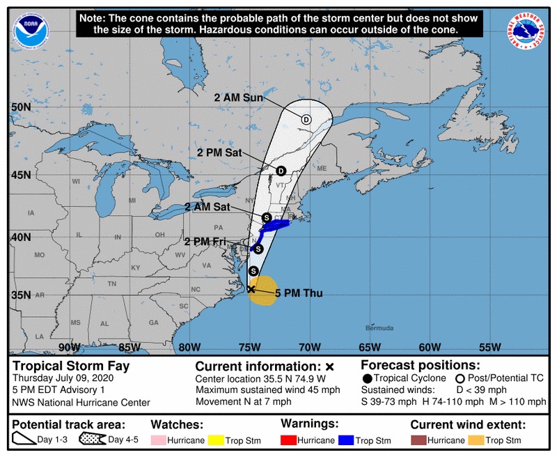
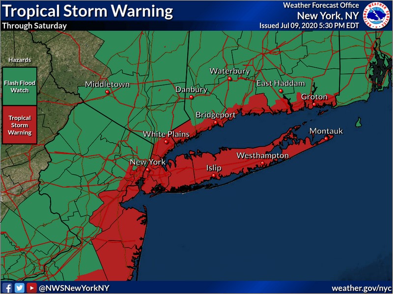
TROPICAL STORM WARNING IN EFFECT... Tropical Storm Fay will bring tropical storm-force winds and heavy rains in to our area through Saturday, July 11,2020
Posted on: July 9, 2020 - 11:54pm
...TROPICAL STORM WARNING IN EFFECT...
A Tropical Storm Warning means tropical storm-force winds are expected somewhere within this area within the next 36 hours
* LOCATIONS AFFECTED
- New Rochelle
- White Plains
- Hastings on Hudson
- New Rochelle
- White Plains
- Hastings on Hudson
* WIND
- LATEST LOCAL FORECAST: Equivalent Tropical Storm force wind
- Peak Wind Forecast: 30-40 mph with gusts to 50 mph
- Window for Tropical Storm force winds: Friday evening until
Friday evening
- LATEST LOCAL FORECAST: Equivalent Tropical Storm force wind
- Peak Wind Forecast: 30-40 mph with gusts to 50 mph
- Window for Tropical Storm force winds: Friday evening until
Friday evening
- THREAT TO LIFE AND PROPERTY THAT INCLUDES TYPICAL FORECAST
UNCERTAINTY IN TRACK, SIZE AND INTENSITY: Potential for wind 39
to 57 mph
- PLAN: Plan for hazardous wind of equivalent tropical storm
force.
- PREPARE: Remaining efforts to protect property should be
completed as soon as possible. Prepare for limited wind
damage.
- ACT: Move to safe shelter before the wind becomes hazardous.
- POTENTIAL IMPACTS: Limited
- Damage to porches, awnings, carports, sheds, and unanchored
mobile homes. Unsecured lightweight objects blown about.
- Many large tree limbs broken off. A few trees snapped or
uprooted, but with greater numbers in places where trees
are shallow rooted. Some fences and roadway signs blown
over.
- A few roads impassable from debris, particularly within
urban or heavily wooded places. Hazardous driving
conditions on bridges and other elevated roadways.
- Scattered power and communications outages.
* STORM SURGE
- No storm surge inundation forecast
- No storm surge inundation forecast
- THREAT TO LIFE AND PROPERTY THAT INCLUDES TYPICAL FORECAST
UNCERTAINTY IN TRACK, SIZE AND INTENSITY: Little to no storm
surge flooding
- PLAN: There is little to no threat of storm surge flooding.
Rough surf, coastal erosion, and life-threatening rip
currents are possible.
- PREPARE: Little to no preparations for storm surge flooding
are needed.
- ACT: Follow the instructions of local officials. Monitor
forecasts.
- POTENTIAL IMPACTS: Little to None
- Little to no potential impacts from storm surge flooding.
- Little to no potential impacts from storm surge flooding.
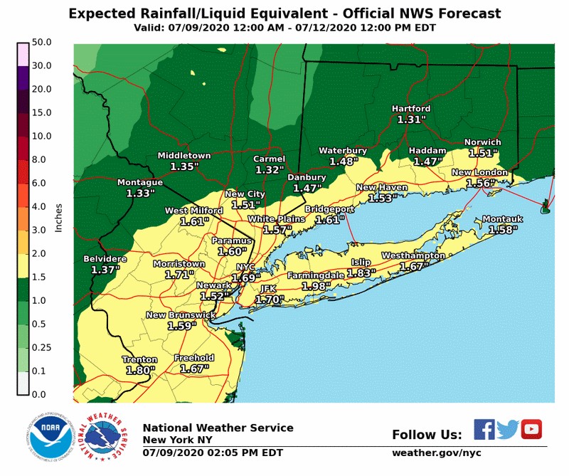
* FLOODING RAIN
- LATEST LOCAL FORECAST: Flash Flood Watch is in effect
- Peak Rainfall Amounts: 1-3 inches, with locally higher
amounts
- Peak Rainfall Amounts: 1-3 inches, with locally higher
amounts
- THREAT TO LIFE AND PROPERTY THAT INCLUDES TYPICAL FORECAST
UNCERTAINTY IN TRACK, SIZE AND INTENSITY: Potential for
moderate flooding rain
- PLAN: Emergency plans should include the potential for
moderate flooding from heavy rain. Evacuations and rescues
are possible.
- PREPARE: Consider protective actions if you are in an area
vulnerable to flooding.
- ACT: Heed any flood watches and warnings. Failure to take
action may result in serious injury or loss of life.
- POTENTIAL IMPACTS: Significant
- Moderate rainfall flooding may prompt several evacuations
and rescues.
- Rivers and streams may quickly become swollen with swifter
currents and may overspill their banks in a few places,
especially in usually vulnerable spots. Small streams,
creeks, canals, and ditches may overflow.
- Flood waters can enter some structures or weaken
foundations. Several places may experience expanded areas
of rapid inundation at underpasses, low lying spots, and
poor drainage areas. Some streets and parking lots take on
moving water as storm drains and retention ponds overflow.
Driving conditions become hazardous. Some road and bridge
closures.
* TORNADO
- LATEST LOCAL FORECAST:
- Situation is somewhat favorable for tornadoes
- LATEST LOCAL FORECAST:
- Situation is somewhat favorable for tornadoes
- THREAT TO LIFE AND PROPERTY THAT INCLUDES TYPICAL FORECAST
UNCERTAINTY IN TRACK, SIZE AND INTENSITY: Potential for a few
tornadoes
- PLAN: Emergency plans should include the potential for a
few tornadoes.
- PREPARE: If your shelter is particularly vulnerable to
tornadoes, prepare to relocate to safe shelter before
hazardous weather arrives.
- ACT: If a tornado warning is issued, be ready to shelter
quickly.
- POTENTIAL IMPACTS: Limited
- The occurrence of isolated tornadoes can hinder the
execution of emergency plans during tropical events.
- A few places may experience tornado damage, along with
power and communications disruptions.
- Locations could realize roofs peeled off buildings,
chimneys toppled, mobile homes pushed off foundations or
overturned, large tree tops and branches snapped off,
shallow rooted trees knocked over, moving vehicles blown
off roads, and small boats pulled from moorings.
* FOR MORE INFORMATION:
- https://keepingsafe.westchestergov.com/severe-weather/hurricanes
- https://giswww.westchestergov.com/gismap/default.aspx?ovmap=hurricane
- https://weather.gov/nyc
- https://ready.gov/hurricanes
- https://keepingsafe.westchestergov.com/severe-weather/hurricanes
- https://giswww.westchestergov.com/gismap/default.aspx?ovmap=hurricane
- https://weather.gov/nyc
- https://ready.gov/hurricanes

CLICK HERE TO "TELL IT TO VILLAGE HALL"
Village of Hastings-on-Hudson
7 Maple Ave, Hastings-on-Hudson, NY 10706
email: Hastings@Hastingsgov.org
STAY CONNECTED! DOWNLOAD ALL OF OUR SMARTPHONE APPS HERE
TO SUBSCRIBE OR UNSUBSCRIBE GO TO http://hastingsgov.org/subscribe
SIGN UP FOR TEXT ALERTS AT: http://hastingsgov.org/subscribe-text
For information regarding access for persons with disabilities, please visit http://hastingsgov.org or call 914-478-3400.
WHoH-TV is on facebook with links to all current meetings & events! Streaming live at WHoH-TV.org!
The Hastings-on-Hudson Technology Department asks that you consider the environment before printing this e-mail.